UAV UGV Roadmap Geomatics & Remote Sensing Infrastructure & Construction Defence & Security Work with us
Services / Infrastructure & Construction

Autonomous site monitoring that never stops.

Continuous aerial and ground-level data capture delivers real-time progress visibility, volumetric accuracy, and safety oversight across every phase of construction.

Progress Tracking

01
Automated Site Capture
Scheduled autonomous flights capture complete site conditions on daily, weekly, or custom intervals. No crew coordination required. Every capture produces a georeferenced 3D model and orthomosaic of the entire site.
+
02
Visual Timeline & Comparison
Side-by-side temporal views reveal exactly what changed between any two capture dates. Overlay planned schedules against actual progress to identify delays before they cascade into cost overruns.
+
03
Stakeholder Dashboards
Web-based dashboards give project managers, clients, and investors real-time visibility without site visits. Track milestones, flag deviations, and generate compliance reports from any device.
+

Volumetric Analysis

04
Cut & Fill Measurement
Calculate earthwork volumes with survey-grade accuracy from aerial data. Compare against design surfaces to track excavation and fill progress, eliminating manual survey delays and reducing measurement disputes.
+
05
Stockpile Inventory
Autonomous stockpile measurement across material yards in minutes, not days. Track aggregate, soil, and material volumes over time to verify deliveries, prevent theft, and optimise procurement.
+

As-Built Verification

06
Design vs. Reality Overlay
Overlay captured 3D models against BIM and design files to identify deviations in real time. Catch misalignments, elevation errors, and specification breaches before concrete is poured, not after.
+
07
Quality Assurance Documentation
Timestamped, georeferenced records of every construction phase create an irrefutable as-built archive. Defend against claims, satisfy regulatory audits, and document handover with centimetre-accurate evidence.
+

Safety Monitoring

08
Hazard Detection
AI-assisted analysis identifies unsafe conditions: missing barriers, unauthorised access, unstable excavations, and PPE non-compliance. Automated alerts reach safety officers in real time, not in next-day reports.
+
09
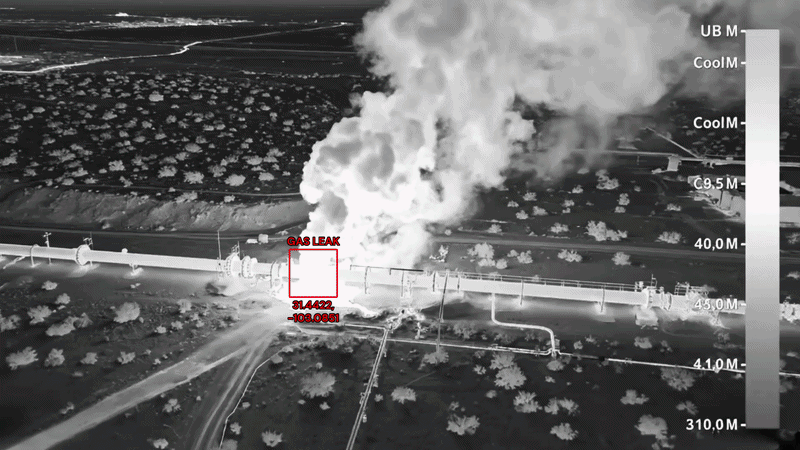
Thermal & Structural Monitoring
Thermal imaging detects moisture ingress, insulation defects, and overheating equipment. Monitor curing concrete temperatures and identify structural anomalies invisible to visual inspection.
Thermal detection
+

BIM Integration

10
Direct BIM Sync
Point clouds and mesh models export directly into Autodesk Revit, Navisworks, and Bentley platforms. Maintain a living digital twin that reflects actual site conditions alongside the design model.
+
11
4D Schedule Linking
Link captured data to project schedules for automated progress quantification. Visual percent-complete tracking against planned timelines gives programme managers the clarity to act decisively.
+

Build with certainty.

Work with us